-
Your Government
-
- City Council Boards & Commissions Public Meetings & Minutes Municipal Code City News
- Departments Administration Building City Recorder Elections Engineering Finance Human Resources Library
- Departments Municipal Court Parks & Recreation Planning Police Public Works Reservoir Project Urban Renewal Utilities
-
-
Our Community
-
- About St. Helens History of St. HelensGeneral Fund InformationState of the CityCourthouse Dock Camera
- Local Events City Calendar Community Day in the Park13 Nights on the RiverIndependence Day Celebration Spirit of HalloweentownRecreation Activities Sand Island CampingKeep It Local CC
- Community Resources City Newsletter City Social Media Emergency Services New Resident InformationProtecting Our EnvironmentClass IV ATV Use
-
-
Business & Development
-
- Local Business Directory Get a Business License City Bids & RFPs Broadband Study
- Business in St. Helens St. Helens Advantages Directions & Transportation Incentives & Financing Resources for Businesses Business Guide Columbia Economic Team Chamber of Commerce
- Current City Projects Waterfront Redevelopment Public Safety Facility Strategic Work Plan
-
-
How Do I?
-
- Apply for a Job Apply for a Committee Find A Park Find COVID Info Find Forms Follow St. Helens - Facebook Follow St. Helens - Twitter Follow St. Helens - YouTube
- Get a Police Report Get a Business License Get a Library Card Get a Building Permit Newsletter Signup Past Public Meetings Pay My Water Bill
- Public Records Request Report a Nuisance Register for Rec Activity Reserve a Park Sign Up for the 911 Alerts Universal Fee Schedule
-
Streets and Utilities Extension Project
Upcoming Meetings
No upcoming community meetings are scheduled.
Subscribe to the Waterfront Newsletter for the latest project updates.
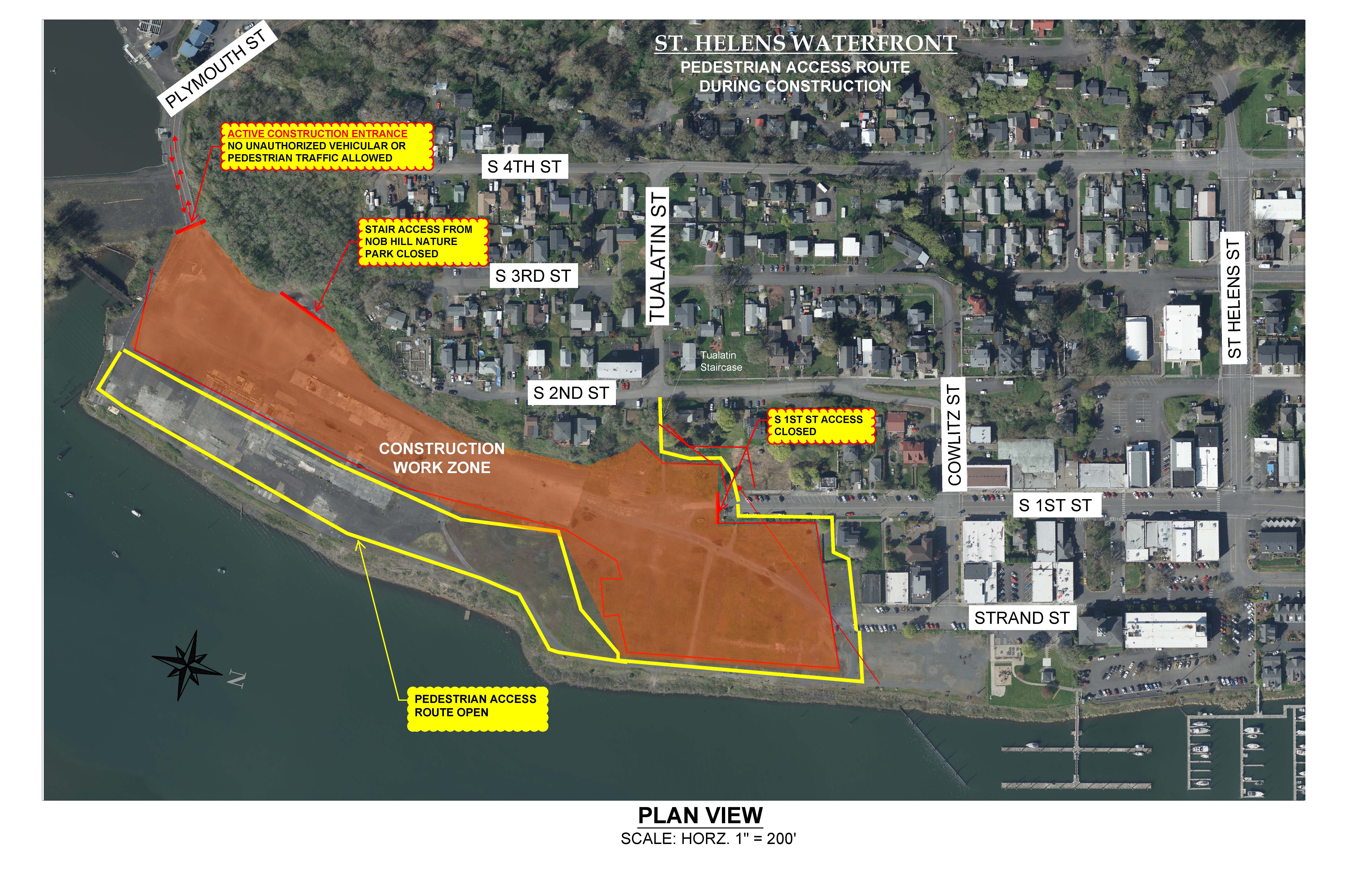
Active Construction Areas
Riverfront Property: Storm retention ponds
Businesses During Construction
St. Helens Riverfront District businesses are open and accessible during construction. We encourage you to continue to shop local. Learn more on our Businesses During Construction page.
Project Summary
The City of St. Helens launched the Streets and Utilities Extension Project in March 2021.
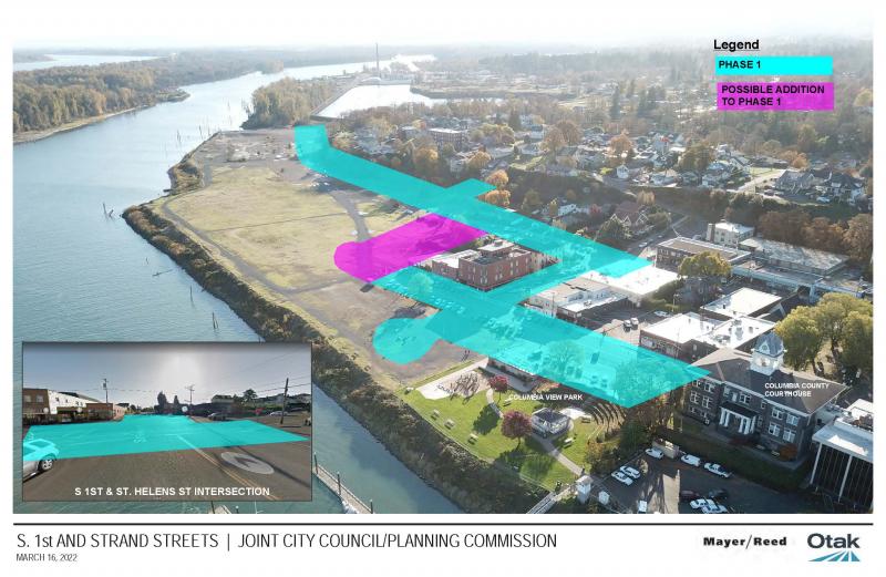
The project is focused on improving key streets and intersections that already exist in the city’s historic Riverfront District and extending utilities onto the City’s 24-acre Riverfront Property. The project, which was launched in 2021, will set the groundwork for future public amenities and private development on the Riverfront Property. The City is interested in partnering with private developers who can build a mix of commercial and residential uses on the site.
The Streets and Utilities Extension Project will improve the safety of existing intersections, create inviting pedestrian connections in the Riverfront District, and increase parking in the area.
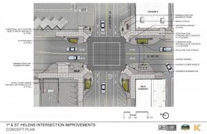 Construction efforts will first be focused on the South 1st Street and St. Helens Street intersection. This intersection serves as a gateway to the city’s historic Riverfront District, welcoming residents and visitors to local businesses, government buildings, and the sites of major community events. The intersection’s new design will improve traffic flow, create safer pedestrian crossings, and install benches and other amenities. A larger version of the intersection design pictured here can be found below under the supporting documents section.
In addition to the South 1st Street and St. Helens Street intersection, the Streets and Utilities Extension Project will also:
- Redesign South 1st Street and Cowlitz Street intersection
- Extend Cowlitz Street onto the Riverfront Property with a turnaround feature which will connect seamlessly to the upcoming Riverwalk Project and Columbia View Park improvements scheduled to begin later in 2023
- Redesign Strand Street to improve traffic safety and create a plaza above Columbia View Park which will serve as a vendor space for events such as 13 Nights on the River
- Extend South 1st Street to the Tualatin Street stairs and create a pedestrian-friendly intersection which will serve as a trailhead for a bluff trail
- Create a bluff trail along the west side of the Riverfront Property that extends from South 1st Street to Nob Hill Nature Park and Plymouth Street
- Extend underground utilities through the Riverfront Property to prepare the site for solicitation of a private development partner(s)
- Fill in gaps in existing sidewalks and create landscaping
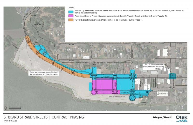
The Streets and Utilities Extension Project is anticipated to take two years to complete. Construction will take place in a phased approach over the two years to allow for street detours and to minimize construction impacts to area residents and local businesses.
Otak, Inc. is the City’s project engineer and Mayer/Reed, Inc. is the City’s landscape architect for the project. The construction contractor is Moore Excavation, Inc. This project is only focused on public infrastructure and does not include any private development component.
The Streets and Utilities Extension Project is one component of the City's Riverfront Project. The Riverfront Project is made up of the Streets and Utilities Extension Project and Riverwalk Project. Phase I of the Riverwalk Project is expected to break ground in 2024. Phase I will expand Columbia View Park onto the Riverfront Property and construct the first phase of a public walkway and boardwalk along the edge of the Columbia River.
The Riverfront Project is a part of the City's overall Waterfront Redevelopment Project efforts.
Stay Informed
The City of St. Helens has launched a Waterfront Redevelopment Newsletter to keep community members informed about project information, construction impacts, and timelines. Subscribe to the newsletter here.
Project Contact Information
For further information regarding the Streets and Utilities Extension Project, please email waterfront@sthelensoregon.gov.
A larger version of the above map can be found below in the supporting documents section.